Sunday, December 23, 2012

Bay Circuit Trail: Concord and the Spirit of Thoreau.


Henry and I go way back. I like to think I appreciate him as he actually was rather than as the wretched plaster saint he's become.

"I'd rather sit on a pumpkin and have it to myself than be crowded on a velvet cushion", is one quote that comes to mind when I end up stuck on the T at rush hour. Henry is like a founding mentor for my American appreciation of this living world and his works form the footing for it. 


The Bay Circuit Trail section of Thoreau country might begin at Concord Center. I usually start at the train station. The first noteworthy open space parcel is the Hapgood Wright Town Forest


Monday, December 10, 2012

Bay Circuit Trail: The Common Wealth of Town Forests.


Town Forests make up a significant part of the Bay Circuit Trail. I've been poring through web searches trying to get a sense of their history and origins here as they appear to be a fairly unique thing.


My best guess is that they are the essence of the Commonwealth design in a time when wood was a core element of the colonial culture as a material and as a fuel. Towns set these tracts aside to provide fuel in winter for town facilities and to provide lumber for town building projects.

Eventually, other fuels replaced wood and lumbering operations were scaled up to the point where dimension stock market lumber was a better value than milling your own. The things entered a long phase of benign neglect until recently revived as the principle open space property a town is likely to have. 

Despite this, they are still mysterious as there isn't any directory of them such as you would find for Commonwealth DCR properties, Federal things like National Wildlife Refuges or the many privately owned properties such as Audubon Sanctuaries or Trustees Reservations.


Sunday, November 18, 2012

Bay Circuit Trail: Duxbury, Thanksgiving Heartland.


My piece on Duxbury last year was seen from afar. I mainly wanted to gather what I could on the place as a form of aggregation content so people would have a handy overview of it.


This year, I was able to actually visit and make video clips of all the open space parcels currently carrying the Bay Circuit Trail

If you live in the area and find yourself wanting to walk off the effects of our national feast day, you would do well to roam the wondrous array awaiting you.


It is the benchmark town for best practices in trail operations in its region, a very good model. There is fairly complete online information about the conservation properties, nice maps that blend art with craft and first rate follow through on the ground operations. 

Rules are enforced regarding motorized things, often by design at trailhead points and yet the rules are congenial and thought through. Dog owners are required to have the dog under control without specifics on how this control is attained. This affixes liability on the owner with minimal specifics.


Saturday, November 3, 2012

Great Marsh Glimpses: Rough Meadows.

The Great Marsh by Martin Johnson Heade.

The Great Marsh extends from the New Hampshire border at the Merrimack mouth to a southern rampart made by Cape Ann. Its bulwarks against the open ocean consist of two chunky barrier strips, Plum Island and Cranes Beach.


The quieter space behind these barriers makes for an outstanding fish nursery, which, in it's turn attracts all manner of food chain participants. 

Another point of wonder is that much of it is fairly intact from encroachment by pollution and invasive species. It has its problems and is vulnerable to rising water that will likely accompany global warming. 

And then, there is the degree of excitement shared by the array of organizations that are converging attend to this bit of grandeur. I went up to that area in September to just cover the basic run of the Bay Circuit Trail from Joppa Flats to the Rowley commuter rail station

On a whim, I imposed myself on the volunteer staff at Joppa Flats and was taken by their excitement about the overall collaboration and the recent opening of the Rough Meadows Wildlife Sanctuary in the heart of it. I left with a Massachusetts Audubon membership renewal, (it's been years), a pile of printed material and an urge to follow up on the prompting of the gracious staff to explore the place.


I was back by the first of October, just at the cusp of the highest monthly tides. I was oblivious to tide timing and walked to the Sawyer Island parcel of the Essex County Greenbelt Association, all the way at the end of the road, first.


These properties belonged to Professor Alfred D Chandler Jr. and became his legacy contribution to this grand undertaking.

"Al loved to hunt, and he was a very good shot. During duck season, he could be found at daybreak in the marshes, then back in his study at midday, then back in the marshes."


The main access road into the Sanctuary passes along a stretch that can be immersed in high tide and so I found myself waiting for it to recede. 


It was an agreeable mission as it forced me to take long bemused looks around and discover things like Salicornia gravid from the brackish water. I also saw a fairly dense mass of infant fish feeding on algae. 

Once the tide let me pass I was free to follow Professor Chandler's Long Walk to its overlook spot to take in the demure vastness of it all.


On the way back I took in the Hickory Trail and Appy's Way. I'll return some day to explore the Sassafras Trail and The Kestral Trail. 

All in all it is an outstanding introduction to the quiet side of the Great Marsh.

Sunday, October 21, 2012

Bay Circuit Trail: Bedford MA Narrow Gauge Rail Trail.


The Narrow Gauge Rail Trail section of the Bay Circuit may well be one of its most striking success stories. 

I took a hike there on 9/11 as Benghazi was aflame and I was stunned to see how vivacious it is on a late summer Tuesday. And it threads through some fairly affluent home areas with a general sense that the trail is a cherished amenity that adds value.

This value is further increased by the run of abutting conservation areas one can visit along the upper two thirds of the route.

Buehler Ponds Conservation Area is the northernmost gift along the trail.


"The Buehler Ponds Conservation Area includes a a 6.4-acre parcel purchased in 1978 with State Self-Help funding and an adjoining 3-acre parcel acquired as a gift in 1987. The .96-acre Lane Farm Conservation Area was donated in 2008, and includes a portion of the upper pond shore and trail. Located adjacent to the north-south railroad bed, these sites contains upland forest, two man-made ponds, gneiss bedrock outcrops marked by glacial scupting, and trails leading around the ponds and south to Job Lane School."

Courtesy of the Bedford Conservation Commission.

The Bay Circuit joins the rail bed from the east via the Governor Winthrop parcel, a short distance south of the Buehler trailhead.

The middle section of the trail begins at Fawn Lake when you are heading south.


"The most visible and valuable conservation area in Bedford owes its popularity to the park-like setting with trails around a 12-acre pond, 2-acre lawn and 25-acre forest, purchased in 1979 with State Self-Help funding. The gift of the 3.5-acre Sheldon Conservation Area in 1992 established a valuable 2.3-acre buffer between Fawn Lake and nearby residential areas. A shrub swamp on the property provides habitat quite different from the Fawn Lake area, and preservation of woodland and swamp on the side of the railroad bed opposite Fawn Lake is extremely important to preservation of the pond's visual attraction.


Fawn Lake's interesting past as a mineral springs health resort and early pharmaceutical center reminds the visitor that the lake has been a scenic and restorative attraction for over a century. Traces of the old mineral springs remain, but present use is more likely to be fishing, boating or strolling around the shore. Native vegetation predominates, and the shore is one of the best places in Bedford to see mountain laurel. Also scattered throughout the site are grand examples of former landscaping, such as Japanese maple, magnolia, wisteria and rhododendron. Parking is available on Sweetwater Avenue or the railroad bed."


Further south, the rail bed passes the Murray Otis York Conservation Area.


"This property was purchased by the Town in 1963 as surplus land from the federal government; partial reimbursement was acquired as Bedford's first State Self-Help Project. The land was conveyed for conservation use, and for some years the Town was required to report to the U.S. Department of the Interior on its status and maintenance. The land contains mature forest and both wooded and open wetland areas. York is accessible from the north-south railroad bed. New trails have been developed and bog bridges have been installed over the wetter areas."
Courtesy of the Bedford Conservation Commission.

Heading south from there, the Bay Circuit departs to cross Bedford center before joining the Reformatory Branch Trail while the Narrow Gauge Rail Trail has a smooth and seamless course to the grand trail junction at Bedford Depot and the Minuteman Bikeway.

Sunday, October 7, 2012

Andover Trail Annals: The Petals of Ballardvale.


Andover has such a long resonance in the echo of my memory that I return to it periodically. One of the high points of my summer was a series of trips to an interesting cluster of conservation parcels grouped around the Ballardvale Commuter Rail station like petals of a flower with the station as the disk. 


The Andover Village Improvement Society parcel, the Vale Reservation, has a trailhead right at the station parking lot. The other three are Conservation Commission parcels and nearly as close. All are valuable support elements for the Shawsheen River.

Vale is on the northwestern side of the Shawsheen with the Pomps Pond/Foster's Island parcel on the opposite bank. 

It leads to the Shawsheen River Reservation to the north and is blessed with a number of elegant and very well constructed boardwalks that get you into stunning wetland epicenters.


Last year saw the addition of a striking and super sturdy truss bridge. The Andover Trails Committee collaborates with AVIS to craft these unique amenities with avid volunteer work.


Pomps Pond was a homestead for a freed slave named Pompey.

"The current name of Pomp's Pond refers to Pompey Lovejoy, a freed slave who built a cabin near the pond on Abbot Road, fished, and farmed nearby land. Pompey Lovejoy died in the 1820s, over a hundred years old."

Courtesy of the Andover Trails Committee.


To the southeast of the station, you'll find Pole Hill, the site of an early leisure travel destination for summer picnics and concerts at the turn of the 20th century.

"At the turn of the century, this area was known as “The Grove”. It boasted a picnic area and a dance hall and attracted people from all over. The Boston and Maine Railroad even had a siding at Pole Hill to accommodate the dancers. There were three camps along the Shawsheen River, one of which served as a refreshment stand. 

When the river was higher, canoes could be rented in Ballardvale for a romantic paddle upstream to “The Grove”. But Pole Hill’s history is not only of good times; after a murder was committed here, the dance hall was closed for good."

Courtesy of the Andover Trails Committee.


And the southwest is home to Serio's Grove, a childhood swimming hole for Jay Leno.

"The Serio family, Frank Sr. and his wife Theresa, moved from Malden in 1932 to a site “off Lowell Junction Rd.” The home had no phone, electricity, or water. Electricity came in about 1935. At the time of their move the property was mostly open land, nothing like the forest that has grown up during the intervening 40 or so years.

Frank Serio Sr. was given recognition as one of the town’s early environmentalists. Soon after moving in he became concerned about the industrial soap being dumped into the river from an upstream chemical company. Through his efforts a plan was developed by the company to eliminate the pollution.

Because of his interests in the environment the Conservation Commission decided to honor Frank Sr. by naming the property after him. In 2008 the property was officially named “Serio’s Grove”. A dedication ceremony was held on the property with many Serio relatives in attendance. Jay Leno, an Andover native who use to rent canoes from Frank Serio Sr. back when Jay was a young boy, sent a DVD to this event congratulating the Serio family."

Courtesy of the Andover Trails Committee.


The group of properties, along with others in the vicinity, can be explored over the course of a day and they are a kaleidoscopic whirl of ecotones.


"Bottle" Gentian in Serio's Grove.


Friday, September 21, 2012

Bay Circuit Trail: Kingston Chronicles.


Kingston, Massachusetts is tucked between Plymouth and Duxbury along the coast and shares the southern end point of the Bay Circuit Trail with the latter.

Shipbuilding was a principle focus for much of its existence. A kernel of that continues at Jones River Landing, the conservation epicenter.

Despite recent attempts by speculators to make it a metro Boston bedroom community, it is essentially rural with an agricultural economy pegged to cranberries.

It's part of a vast sand swath that also defines Cape Cod, the islands and parts of Long Island. As such it was never too well suited for farming, lacked any minerals to generate wealth and isn't a tourist destination.

It brings to mind the sand county lands of Wisconsin beloved by Aldo Leopold


All that aside, it has an impressive array of conservation properties along the Jones River, which will ever be the living core of whatever human efforts may meet it.


Following the Bay Circuit Trail description for the area, we first encounter the Silver Lake Sanctuary near the Pembroke border. 

It is one of three parcels acquired between 1997 and 1999 amid a property speculation boom fueled by the restoration of commuter rail. I used the Halifax station as my initial point of entry and it is quite helpful.


From there the trail heads to the Cranberry Watershed Preserve via an unusually demure and unmarked trailhead south of the high school on Lake Street.

It took me several visits over August and September to get the routes right because of blazing absence but diligence gets results. The problem appears to be a higher incidence of vandalism than is common elsewhere wedded to a readily evident lack of support from the towns principle decision makers.

The town website tells the story. Effort is lavished on a web presence for a youth recreational initiative, worthy enough, but most useful links for land preserves are either broken, incomplete or have an unusually long loading time.

As a consequence, there is very little mapping online for individual tracts and what there is is fairly unusable.While the shift from boom to bust that followed the Great Recession can partially account for the absence of support for the properties, there was no such excuse during the prior boom phases that followed 2000.

The vandalism appears to express conflicts my own town experienced in the late 60s. The commuter rail boom brought an additional 3000 plus residents into the town in a fairly short period with predictable stresses on every service aspect and a corresponding deficit strain on town coffers.


Thus the long standing residents saw their tax rates spike without much in the way of service improvement and an influx of people who increasingly were at odds with their rural traditions involving various noisy motorized recreation contraptions.


The Hathaway Preserve appears to have borne the brunt of this. It happens to be bisected by utility power lines that were long preferred corridors for these things and attempts to assert noisy RV prerogatives find their focus there.


And this is complicated by an evident corridor easement failure at one particularly good route run leading to a trail to nowhere that is nonetheless quite wonderful. You end up with a veritable twilight zone of a tract that is thankfully small so a half a day of exploration will unravel most of its knots.


From there, the trail heads to the fourth major tract carrying the Bay Circuit and it is the oldest of them all,  Sampson Park, a completely charming old place with some man made trail features that look as if pilgrims made them. It is in very good condition but also suffers from blazing problems.


At the end of the day, a dedicated community volunteer initiative could probably fix many of these minor defects in short order and with minimal fuss. 

Kingston also shares ownership of Bay Farm with Duxbury where the southern end of the Bay Circuit meets the sea. That place will get its own special post.

Monday, August 20, 2012

Bay Circuit Trail: Walpole to Sharon Commuter Rail Loop.

Old Sawmill Pond, Walpole Town Forest

The Bay Circuit Trail and the Neponset River watershed intertwine gloriously here where commuter rail enables one of the more outstanding hikes in the system.


I've come to agree with Colonel Powell that the watershed may well be the primary unit of geographic organization and will increasingly orient content along that bearing.


I initially planned to enter the hike from Sharon and take it to Walpole but I ended up switching to follow the alignment of the trail description


This worked really well as you start from the river basin areas of Walpole and gradually rise to Moose Hill in Sharon.


Along the Bluffs Trail, Moose Hill Wildlife Sanctuary.

Another great facet of it is how the array of places along the route offer something for many diverse constituents. The extensive Town Forest tracts in Walpole work very well for trail running and biking while the more restricted portions in the Massachusetts Audubon Society lands are veritable area nature cathedrals.


The hike is generally relatively easy to follow and trail marking is particularly impeccable in Sharon, where the Warner Trail joins the Bay Circuit . I noticed that it shares a basic sandy soil matrix with Kingston on the coast suggesting the deposition patterns of relatively rapid glacial retreat that make an underpinning for the southern Bay Circuit's distinct array of ecotones.

The walk to the Sharon commuter rail station from Moose Hill is all down hill.


Courtesy Massachusetts Dept. of Conservation and Recreation.

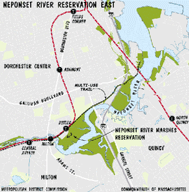
The Neponset Estuary is also well lined with reservations and tracts and is an outstanding easy day visit by subway. It provides a great sense of basic riparian continuity dating back to the 1600s.


Neponset Estuary at Granite St Bridge.


There is a plan underway to join these elements until the Neponset Trail eventually meets the Warner Trail.The Walpole commuter rail run gives a sense of the route. 


Monday, August 6, 2012

Charles River Link Trail: Riverside T Station to Wellesley Hills.


This spoke trail is a close counterpart to Minuteman Bikeway in terms of easy public transportation proximity to great hike options.


It is a subtler thing, though. It's mainly a shanks mare adventure. Wellesley has an exceptional conservation land system

The northern trail head is a 20 minute walk from the Riverside T Station along Grove St. in Newton Lower Falls, a sub-village of Newton. The entrance is a charming footbridge


On the southerly bank lies Wellesley, a town invented by a banker during the gilded age at the end of the 19th century.

I followed it for a few miles and soon came to a single track segment through a floodplain forest along the Charles before it veers away from the river near Ouellet Playground.

From there, it is a fairly short street traverse before you reach the northern entrance to Wellesley Town Forest.


The forest is particularly well equipped with eskers. This array includes the tallest one I've run across yet at 160 feet.


From the southern end at the Longfellow Pond parking lot, it is a fairly short walk to the Wellesley Hills commuter rail station.


The Charles River Link Trail is an outstanding community effort and runs all the way to Medfield.

Longfellow Pond, Wellesley MA

Wednesday, July 25, 2012

Bay Circuit Trail: Ashland Aspects.


The "Proposed" Ashland Commuter Rail Station.


I made a recent trip to Ashland and decided to get a basic orientation of the rail station to the nearest Bay Circuit trail segment, a short trek down Ponderosa Road


One comic aspect of it is that many maps, including Google, indicate the station is 'proposed' when it's clearly been in existence since I passed it one September night in 2006 on a transcontinental Amtrak. 


And you thought digitization would lead to lightening speed updates and molecular levels of descriptive accuracy. Naaah.


And, what's funnier, it is clear that some workmanship shoddiness has already occurred.


The relatively new metal under-structures exhibit significant corrosion which may be attributable to poor sealing of the concrete pouring beds. The winter freeze/thaw cycles have led to seepage of the highly corrosive ice melt salts to a degree where it even attacks the all weather galvanized stuff. It's either a bad design or slipshod execution or some combination.


But that's a mere digression. Ashland is out at the furthest western edge of the Bay Circuit and has its own impressive endowment of amenities.


The Bay Circuit Trail passes fairly close to the station coming down from Sudbury and the Town Forest  to the north to follow a stretch of the Sudbury River east before heading south. 


Ashland DPW Salt Shed.


The nearest north bound trail access walking from the train station is just beyond a salt storage shed at Ashlands  DPW complex. 


The south bound counterpart is along an old river side driveway at the DPW complex lot entrance. It trends easterly toward Sherborn.


 Along the way are options for a history walk conceived by the historical society with additional amenities along the south side of town including Ashland State Park.


Ashland State Park.

"The Town of Ashland's ideal location midway between Boston and Worcester provides easy access to the interstate highway system and the Massachusetts Turnpike. Ashland was, in earlier times, a stopping point on a major Indian trail which later became known as the Bay Path, connecting Cambridge and Connecticut. It was here that a community of Natick Indians was established as the Village of Magunkaquog in about 1659. Once the original starting point of the world famous Boston Marathon, which still runs through Ashland, the town is also known as the site of Henry Warren's invention of the electric clock, later manufactured here under the Telechron name."
Succinct Summary from the Town.

A recent source of excitement among local land conservation enthusiasts was the town's acquisition of Warren Woods from Northeastern University. All in all it is a town well situated for a sustainable future.  

Wednesday, July 18, 2012

Bay Circuit Trail: The Reformatory Branch, Bedford MA.


Bedford Depot.


The Bay Circuit ‘hub’  in the  urban core has a number of trail  ‘spokes’ in addition to those formed by the public transit system. Of these, the most prominent is easily the Minuteman Bikeway, a paved marvel along the old railway line through Arlington and Lexington to Bedford. I’ve pedaled its 11 miles on a few occasions, weekdays are often the least crowded. 


Once at the Bedford Depot, one has the option of running the old Narrow Gauge line to its eventual dissolution in Billerica or heading west along the Reformatory Branch to Great Meadows in Concord.


The Narrow Guage is probably better prepared for biking while the Reformatory Branch is more rustic. It is a significant part of the Bay Circuit Trail and allows a look at the headwaters of the Shawsheen and the Concord River on the same day hike or dog walk.

“The Boston & Maine Railroad’s Reformatory Branch was built in 1873 to Lowell Road in Concord and in 1879 it was continued 2.5 miles further west to Reformatory Station (across from the State Prison).


There were four passenger stations on the line: Shady Hill, West Bedford, Concord and Reformatory. The branch was abandoned in 1962, and the right-of-way was purchased by Bedford and Concord.”

Friends of Bedford Depot Park.

It is the nearest Bay Circuit access point from Cambridge and one can take the 62 bus line to the trail head. The return trip out of Concord can have some interesting commuter rail and bus combinations as well. I gave them a test run on July 3rd while many were heading into the holiday.

I got the 6:40am bus out of Alewife T station. It puts you there at around 7:10am. I lived in the area between October 2006 and February 2008 so I was looking forward to getting a sense of how it is doing.


The Elm Brook Conservation Area is the first parcel one encounters along the hike when approaching from the east. It is the birth zone for the Shawsheen watershed with a 19th century stone work culvert to carry Mungo Brook beneath the railbed.


The trail then goes through a fairly mundane stretch of white pine stage reclamation forest before meeting the old Shady Hill Station area. A number of trail side rail relics remain. 


The Mary Putnam Webber Conservation Area soon follows.


"This 20-acre parcel was given to the Town in 1990 for the purpose of protecting uplands and sensitive wetlands from proposed development as a state landfill. Although the landfill was not constructed, the Town recognized the importance of this area to the conservation of natural resources and neighborhood character. The land supports both mature oak forest and white pine groves, surrounding a certified vernal pool containing wood frog habitat. Located adjacent to the east-west railroad bed/bikepath, the land is accessible from either Concord or Hartwell Road.  Management goals include control of brush dumping and off-road vehicles."     TM Bedford Conservation Commission.


My return to the place was interesting. It seems to have been put on a back burner, probably due to the Recession and a shortage of trail volunteers. It is also moving to a stage of succession where alder shrub thickets form in the old meadows so the scarce meadow ecotone spaces are shrinking. It is still part of a fairly robust mix of habitats along the northern margin of Hanscom Field.


The Route 62 parking lot is just a bit further along and marks the point where the trail turns south toward Concord and Great Meadows.


There has been considerable interest since 2007, at least, in making the trail an extension of the Minuteman Bikeway and $210,000.00 was applied by the town of Bedford for a study to estimate the cost of applying pavement to the specs determined by the Commonwealth.


This, in turn, has occasioned opposing outlooks from those who would keep the relative quiet of the walk as it is with some dread evinced over expansion of the robust multi mode torrent of users found on the existing run of the Minuteman.


I find myself in some middle ground. Much as I like lo-fi trail systems and walking, this particular rail bed is about as well located and as suitable as it gets for any further expansion of bicycle arterials. For now, it seems as though the lingering economic sluggishness has worked to keep the whole scheme on ice. 


That side of Bedford also has a fairly quiet secondary road net that works well for bicycles and lacks the terrifying traffic messes one finds along Great Road south of the Center where half of the southbound route 3 traffic seems to insist on a 'shortcut' through Bedford for a slightly better exit position on 128.


Maybe the near term outcome will be to let it be as it is. This will probably appeal to 'Bear' and his human.