Monday, August 20, 2012

Bay Circuit Trail: Walpole to Sharon Commuter Rail Loop.

Old Sawmill Pond, Walpole Town Forest

The Bay Circuit Trail and the Neponset River watershed intertwine gloriously here where commuter rail enables one of the more outstanding hikes in the system.


I've come to agree with Colonel Powell that the watershed may well be the primary unit of geographic organization and will increasingly orient content along that bearing.


I initially planned to enter the hike from Sharon and take it to Walpole but I ended up switching to follow the alignment of the trail description


This worked really well as you start from the river basin areas of Walpole and gradually rise to Moose Hill in Sharon.


Along the Bluffs Trail, Moose Hill Wildlife Sanctuary.

Another great facet of it is how the array of places along the route offer something for many diverse constituents. The extensive Town Forest tracts in Walpole work very well for trail running and biking while the more restricted portions in the Massachusetts Audubon Society lands are veritable area nature cathedrals.


The hike is generally relatively easy to follow and trail marking is particularly impeccable in Sharon, where the Warner Trail joins the Bay Circuit . I noticed that it shares a basic sandy soil matrix with Kingston on the coast suggesting the deposition patterns of relatively rapid glacial retreat that make an underpinning for the southern Bay Circuit's distinct array of ecotones.

The walk to the Sharon commuter rail station from Moose Hill is all down hill.
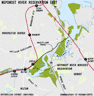


Courtesy Massachusetts Dept. of Conservation and Recreation.

The Neponset Estuary is also well lined with reservations and tracts and is an outstanding easy day visit by subway. It provides a great sense of basic riparian continuity dating back to the 1600s.


Neponset Estuary at Granite St Bridge.


There is a plan underway to join these elements until the Neponset Trail eventually meets the Warner Trail.The Walpole commuter rail run gives a sense of the route. 


Monday, August 6, 2012

Charles River Link Trail: Riverside T Station to Wellesley Hills.


This spoke trail is a close counterpart to Minuteman Bikeway in terms of easy public transportation proximity to great hike options.


It is a subtler thing, though. It's mainly a shanks mare adventure. Wellesley has an exceptional conservation land system

The northern trail head is a 20 minute walk from the Riverside T Station along Grove St. in Newton Lower Falls, a sub-village of Newton. The entrance is a charming footbridge


On the southerly bank lies Wellesley, a town invented by a banker during the gilded age at the end of the 19th century.

I followed it for a few miles and soon came to a single track segment through a floodplain forest along the Charles before it veers away from the river near Ouellet Playground.

From there, it is a fairly short street traverse before you reach the northern entrance to Wellesley Town Forest.


The forest is particularly well equipped with eskers. This array includes the tallest one I've run across yet at 160 feet.


From the southern end at the Longfellow Pond parking lot, it is a fairly short walk to the Wellesley Hills commuter rail station.


The Charles River Link Trail is an outstanding community effort and runs all the way to Medfield.

Longfellow Pond, Wellesley MA

Wednesday, July 25, 2012

Bay Circuit Trail: Ashland Aspects.


The "Proposed" Ashland Commuter Rail Station.


I made a recent trip to Ashland and decided to get a basic orientation of the rail station to the nearest Bay Circuit trail segment, a short trek down Ponderosa Road


One comic aspect of it is that many maps, including Google, indicate the station is 'proposed' when it's clearly been in existence since I passed it one September night in 2006 on a transcontinental Amtrak. 


And you thought digitization would lead to lightening speed updates and molecular levels of descriptive accuracy. Naaah.


And, what's funnier, it is clear that some workmanship shoddiness has already occurred.


The relatively new metal under-structures exhibit significant corrosion which may be attributable to poor sealing of the concrete pouring beds. The winter freeze/thaw cycles have led to seepage of the highly corrosive ice melt salts to a degree where it even attacks the all weather galvanized stuff. It's either a bad design or slipshod execution or some combination.


But that's a mere digression. Ashland is out at the furthest western edge of the Bay Circuit and has its own impressive endowment of amenities.


The Bay Circuit Trail passes fairly close to the station coming down from Sudbury and the Town Forest  to the north to follow a stretch of the Sudbury River east before heading south. 


Ashland DPW Salt Shed.


The nearest north bound trail access walking from the train station is just beyond a salt storage shed at Ashlands  DPW complex. 


The south bound counterpart is along an old river side driveway at the DPW complex lot entrance. It trends easterly toward Sherborn.


 Along the way are options for a history walk conceived by the historical society with additional amenities along the south side of town including Ashland State Park.


Ashland State Park.

"The Town of Ashland's ideal location midway between Boston and Worcester provides easy access to the interstate highway system and the Massachusetts Turnpike. Ashland was, in earlier times, a stopping point on a major Indian trail which later became known as the Bay Path, connecting Cambridge and Connecticut. It was here that a community of Natick Indians was established as the Village of Magunkaquog in about 1659. Once the original starting point of the world famous Boston Marathon, which still runs through Ashland, the town is also known as the site of Henry Warren's invention of the electric clock, later manufactured here under the Telechron name."
Succinct Summary from the Town.

A recent source of excitement among local land conservation enthusiasts was the town's acquisition of Warren Woods from Northeastern University. All in all it is a town well situated for a sustainable future.